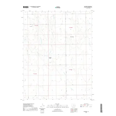
2019 Map of Big Spring
USGS Topo · Published 2019About this map
Mount Pearl sits as a quiet landmark in the high plains of Cheyenne County, where the landscape is defined by the dendritic drainage of the Big Spring creek system. This 2019 survey captures the modern ranching and agricultural grid of eastern Colorado, anchored by the namesake Big Spring and the small settlement at Fort Big Spring. The map documents a complex network of waterways, including Little Spring Cr, Middle Fork Big Spring Cr, and E Fork Big Spring Cr, which carve subtle relief into the terrain. Rising above the drainages, Eureka Hill provides a distinct topographic point of reference. The region is interlaced with a strictly organized section-line road system, from Co RD DD in the north down to Co RD V in the south, reflecting the enduring legacy of the Public Land Survey System in this open range country.
Find a feature on this map
22 named features on this map. Tap any name to fly to it.
Don’t see what you’re looking for? This feature index may not catch every label — zoom into the map to look around manually.
Map Details
Editions of this 2019 Big Spring Map
This is the sole edition of this map. No revisions or reprints were ever made.
Other maps of this area

1891 · Kit Carson
USGS Topo · 1:125,000

1893 · Kit Carson
USGS Topo · 1:125,000

1954 · Limon
USGS Topo · 1:250,000

1954 · Lamar
USGS Topo · 1:250,000

1957 · Limon
USGS Topo · 1:250,000

1958 · Limon
USGS Topo · 1:250,000

1958 · Lamar
USGS Topo · 1:250,000

1979 · Stratton 3 SE
USGS Topo · 1:24,000
1979 · Stratton 3 SW
USGS Topo · 1:24,000
1979 · Alpine Ranch SW
USGS Topo · 1:24,000