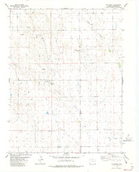
1982 Map of Big Spring
USGS Topo · Published 1982About this map
Fort Big Spring (Ruins) serves as a primary historical anchor in this high plains landscape of Cheyenne County. The topography is defined by the drainage networks of Big Spring Creek and Little Spring Creek, which converge amidst the draws and ridges of eastern Colorado. Local elevations are marked by prominent points such as Eureka Hill and Mount Pearl, while the Middle Fork and East Fork of the drainage system dictate the local relief. The presence of a Landing Strip and multiple instances of a Gravel Pit suggest a landscape geared toward utility and local infrastructure. This 1982 edition, based on earlier field work, provides a detailed view of the water sources so critical to this arid region, including the eponymous Big Spring and various other Springs that once sustained travelers and early frontier outposts.
Find a feature on this map
12 named features on this map. Tap any name to fly to it.
Don’t see what you’re looking for? This feature index may not catch every label — zoom into the map to look around manually.
Map Details
Editions of this 1982 Big Spring Map
This is the sole edition of this map. No revisions or reprints were ever made.
Other maps of this area

1891 · Kit Carson
USGS Topo · 1:125,000

1893 · Kit Carson
USGS Topo · 1:125,000

1954 · Limon
USGS Topo · 1:250,000

1954 · Lamar
USGS Topo · 1:250,000

1957 · Limon
USGS Topo · 1:250,000

1958 · Limon
USGS Topo · 1:250,000

1958 · Lamar
USGS Topo · 1:250,000

1979 · Stratton 3 SE
USGS Topo · 1:24,000
1979 · Stratton 3 SW
USGS Topo · 1:24,000
1979 · Alpine Ranch SW
USGS Topo · 1:24,000