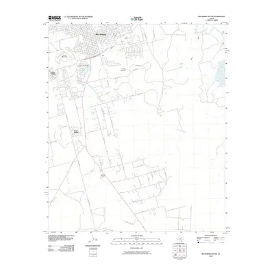
2010 Map of Big Spring South
USGS Topo · Published 2010About this map
Big Spring serves as the focal point of this West Texas landscape, where the urban grid meets the elevated terrain of the Llano Estacado. The area is defined by notable geographic features like Scenic Mountain and South Mountain, which overlook the expanding residential reaches of Webb Village and South Haven. Water management is central to the local geography, visible through the Comanche Lake Dam and the waters of Cosden Lake. The map details a complex drainage network including Elbow Creek and Moss Creek, alongside the namesake Big Spring water body. To the south, Trinity Memorial Park stands as a significant landmark amidst a growing network of local roads such as Parkway Rd and Hughes Rd, illustrating the modern development patterns of Howard County as it appeared in the early 21st century.
Find a feature on this map
51 named features on this map. Tap any name to fly to it.
Don’t see what you’re looking for? This feature index may not catch every label — zoom into the map to look around manually.
Map Details
Editions of this 2010 Big Spring South Map
This is the sole edition of this map. No revisions or reprints were ever made.
Other maps of this area

1941 · Morita
USGS Topo · 1:62,500

1941 · Big Spring South
USGS Topo · 1:62,500

1942 · Big Spring South
USGS Topo · 1:62,500

1942 · Big Spring North
USGS Topo · 1:62,500

1949 · Morita
USGS Topo · 1:62,500

1954 · Big Spring
USGS Topo · 1:250,000

1954 · Big Spring North
USGS Topo · 1:24,000

1958 · Big Spring
USGS Topo · 1:250,000

1965 · Big Spring North
USGS Topo · 1:24,000
1966 · Lucian Wells Ranch
USGS Topo · 1:24,000