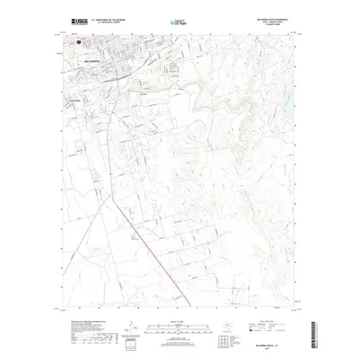
2019 Map of Big Spring South
USGS Topo · Published 2019About this map
Big Spring serves as the focal point of this West Texas landscape, where the urban grid gives way to a complex system of draws and ephemeral creeks. The settlement pattern is defined by the intersection of major transit corridors like W FM 700 and Ranch Rd 33, which connect the community to the surrounding Howard County terrain. Notable landmarks such as Scenic Mtn and South Mtn rise above the drainage basins of Big Spring Draw and Elbow Cr, illustrating the rugged topography that shaped the city's development.
Find a feature on this map
53 named features on this map. Tap any name to fly to it.
Don’t see what you’re looking for? This feature index may not catch every label — zoom into the map to look around manually.
Map Details
Editions of this 2019 Big Spring South Map
This is the sole edition of this map. No revisions or reprints were ever made.
Other maps of this area

1941 · Morita
USGS Topo · 1:62,500

1941 · Big Spring South
USGS Topo · 1:62,500

1942 · Big Spring South
USGS Topo · 1:62,500

1942 · Big Spring North
USGS Topo · 1:62,500

1949 · Morita
USGS Topo · 1:62,500

1954 · Big Spring
USGS Topo · 1:250,000

1954 · Big Spring North
USGS Topo · 1:24,000

1958 · Big Spring
USGS Topo · 1:250,000

1965 · Big Spring North
USGS Topo · 1:24,000
1966 · Lucian Wells Ranch
USGS Topo · 1:24,000