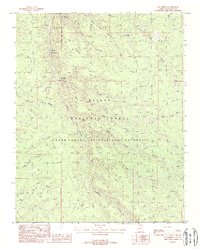
1988 Map of Big Springs
USGS Topo · Published 1988About this map
Big Springs serves as the focal point of this high-plateau survey, situated near a Ranger Station and a notable Lookout Tower within the Kaibab National Forest. The landscape is defined by the deep incisions of Moquitch Canyon, Riggs Canyon, and Sowats Canyon, which transition into the Grand Canyon National Game Preserve. Water sources are vital markers across this arid terrain, including several named points such as Mourning Dove Spring, Mangum Springs, and the artificial catchment at Sawmill Tank. The map also traces the Gila and Salt River Meridian, a critical surveying boundary for Arizona. The presence of a Gravel Pit and established canyon trails suggests the balance between resource management and conservation in this part of Coconino County during the late 1980s.
Find a feature on this map
36 named features on this map. Tap any name to fly to it.
Don’t see what you’re looking for? This feature index may not catch every label — zoom into the map to look around manually.
Map Details
Editions of this 1988 Big Springs Map
2 editions found
Other maps of this area

1886 · Kaibab
USGS Topo · 1:250,000

1936 · Jacobs Lake
USGS Topo · 1:48,000

1940 · Jacob Lake
USGS Topo · 1:62,500

1953 · Jacobs Lake
USGS Topo · 1:62,500

1953 · Grand Canyon
USGS Topo · 1:250,000

1957 · Grand Canyon
USGS Topo · 1:250,000

1958 · Grand Canyon
USGS Topo · 1:250,000

1958 · Big Springs
USGS Topo · 1:62,500

1960 · Grand Canyon
USGS Topo · 1:250,000

1962 · De Motte Park
USGS Topo · 1:62,500