
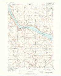
1954 Map of Big Stone Lake
USGS Topo · Published 1956About this map
Big Stone Lake carves through the landscape along the border of South Dakota and Minnesota, serving as the focal point for this mid-century survey. Along its western banks, Hartford Beach State Park and Lake Wilcox offer a look at the region’s recreational geography, while the surrounding prairie is dotted with the remnants of an earlier rural school system. Numerous small educational sites, such as the Golden Prairie Sch and Pleasant View Sch, are marked as abandoned, signaling a shift in the local social structure as farming communities consolidated.
Find a feature on this map
56 named features on this map. Tap any name to fly to it.
Don’t see what you’re looking for? This feature index may not catch every label — zoom into the map to look around manually.
Map Details
Editions of this 1954 Big Stone Lake Map
2 editions found
Other maps of this area

1916 · Peever
USGS Topo · 1:62,500

1916 · Beardsley
USGS Topo · 1:62,500

1918 · Peever
USGS Topo · 1:62,500

1918 · Beardsley
USGS Topo · 1:62,500

1950 · Graceville
USGS Topo · 1:62,500

1953 · Ortonville
USGS Topo · 1:62,500

1953 · Bellingham
USGS Topo · 1:62,500

1953 · Milbank
USGS Topo · 1:250,000

1958 · Milbank
USGS Topo · 1:250,000

1971 · Big Stone Lake East
USGS Topo · 1:24,000