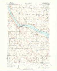
1954 Map of Big Stone Lake
USGS Topo · Published 1956About this map
Big Stone Lake anchors this 1954 survey of the borderlands between South Dakota and Minnesota, revealing a rural landscape defined by a high density of country schoolhouses and small cemeteries. The lake’s shoreline is punctuated by notable landmarks like Salmonson Point, Lou Point, and Goose Island, with Hartford Beach State Park providing a public focal point for the region. The southern portion of the map is dominated by the Whetstone River and its forks, as well as the path of the Chicago Milwaukee St Paul and Pacific railroad crossing the drainage area of the South Fork.
Find a feature on this map
57 named features on this map. Tap any name to fly to it.
Don’t see what you’re looking for? This feature index may not catch every label — zoom into the map to look around manually.
Map Details
Editions of this 1954 Big Stone Lake Map
2 editions found
Other maps of this area

1916 · Peever
USGS Topo · 1:62,500

1916 · Beardsley
USGS Topo · 1:62,500

1918 · Peever
USGS Topo · 1:62,500

1918 · Beardsley
USGS Topo · 1:62,500

1950 · Graceville
USGS Topo · 1:62,500

1953 · Ortonville
USGS Topo · 1:62,500

1953 · Bellingham
USGS Topo · 1:62,500

1953 · Milbank
USGS Topo · 1:250,000

1954 · Big Stone Lake
USGS Topo · 1:62,500

1958 · Milbank
USGS Topo · 1:250,000