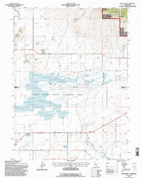
1993 Map of Big Swamp
USGS Topo · Published 1996About this map
Ash Creek State Wildlife Area dominates the central portion of this landscape, where the hydrology of Big Valley creates the extensive wetlands of Big Swamp. The map details a complex system of water management, including a prominent Levee, several canals, and numerous water sources like Service Spring and O'Neals Springs. Cultural history is anchored by Lookout Rancheria and the settlement at Hays, while a lone Cemetery and various Storage Bins suggest the agricultural and community foundations of the region in the early 1990s. The northeastern corner transitions into the high-elevation terrain of Modoc National Forest, marked by Barber Ridge and Major Canyon. Geothermal features are also present, noted by Kellog Hot Springs and other Hot Springs near the southern Modoc Co Lassen Co boundary.
Find a feature on this map
33 named features on this map. Tap any name to fly to it.
Don’t see what you’re looking for? This feature index may not catch every label — zoom into the map to look around manually.
Map Details
Editions of this 1993 Big Swamp Map
This is the sole edition of this map. No revisions or reprints were ever made.
Other maps of this area

1886 · Alturas
USGS Topo · 1:250,000

1886 · Modoc Lava Bed
USGS Topo · 1:250,000

1892 · Modoc Lava-Bed
USGS Topo · 1:250,000

1892 · Alturas
USGS Topo · 1:250,000

1954 · Alturas
USGS Topo · 1:250,000

1958 · Alturas
USGS Topo · 1:250,000

1961 · Canby
USGS Topo · 1:62,500

1961 · Bieber
USGS Topo · 1:62,500

1962 · Alturas
USGS Topo · 1:250,000

1962 · Crank Mountain
USGS Topo · 1:62,500