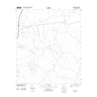
2012 Map of Big Swamp
USGS Topo · Published 2012About this map
The Wolf River and its complex network of tributaries, including Beaverdam Cr and Alligator Cr, dominate this section of Pearl River County in the early 21st century. The landscape is defined by low-lying wetland features such as Big Brake and Waterhole Brake, reflecting the area's name. Local heritage is deeply embedded in the rural road network, with many thoroughfares named for families, such as Harry Davis Rd, Oscar Lee Rd, and Ervin Lee Rd. Small family cemeteries like Beall Cem, Bond Cem, and Rester Cem are scattered across the terrain, serving as vital markers for genealogical research in this sparsely populated region. Industrial activity is noted by the presence of the American Sand and Gravel Rd, while the Bilbo Lookout Tower near Bilbo stands as a prominent navigational landmark in the southwestern corner.
Find a feature on this map
86 named features on this map. Tap any name to fly to it.
Don’t see what you’re looking for? This feature index may not catch every label — zoom into the map to look around manually.
Map Details
Editions of this 2012 Big Swamp Map
This is the sole edition of this map. No revisions or reprints were ever made.
Other maps of this area

1953 · Mobile
USGS Topo · 1:250,000

1955 · Savannah
USGS Topo · 1:62,500

1957 · Mobile
USGS Topo · 1:250,000

1958 · Carnes
USGS Topo · 1:62,500

1958 · Picayune
USGS Topo · 1:62,500

1959 · Poplarville
USGS Topo · 1:62,500

1960 · Mobile
USGS Topo · 1:250,000

1963 · Mobile
USGS Topo · 1:250,000

1965 · Mobile
USGS Topo · 1:250,000
1982 · Savannah
USGS Topo · 1:24,000