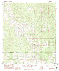
1982 Map of Savannah
USGS Topo · Published 1983About this map
Savannah and Rowlands anchor this landscape along the border of Pearl River and Hancock counties, illustrating the rural character of southern Mississippi in the early 1980s. The terrain is defined by a dense network of drainage, where Catahoula Creek and Redfish Creek carve through the timbered hills. This provisional survey captures local landmarks such as Gilberts Lake and reveals a network of named timber and access routes including Upper Little Creek Road and West Crane Creek Rd. For genealogists, the map identifies specific burial sites like Steep Hollow Cem and Anner Cem, which provide essential geographic context for family histories in these Piney Woods communities. The transition between the two counties is marked clearly, showing how the local road system, including Sand Hill Road, navigated the winding paths of Hickory Creek and Crane Creek.
Find a feature on this map
17 named features on this map. Tap any name to fly to it.
Don’t see what you’re looking for? This feature index may not catch every label — zoom into the map to look around manually.
Map Details
Editions of this 1982 Savannah Map
This is the sole edition of this map. No revisions or reprints were ever made.
Other maps of this area

1953 · Mobile
USGS Topo · 1:250,000

1955 · Savannah
USGS Topo · 1:62,500

1957 · Mobile
USGS Topo · 1:250,000

1958 · Carnes
USGS Topo · 1:62,500

1958 · Picayune
USGS Topo · 1:62,500

1959 · Poplarville
USGS Topo · 1:62,500

1960 · Mobile
USGS Topo · 1:250,000

1963 · Mobile
USGS Topo · 1:250,000

1965 · Mobile
USGS Topo · 1:250,000
1982 · Necaise
USGS Topo · 1:24,000