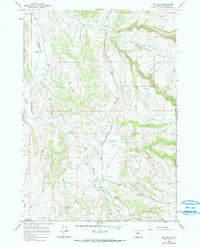
1966 Map of Big Trails
USGS Topo · Published 1990About this map
Big Trails serves as the primary focal point of this high-desert ranching landscape in south-central Washakie County, centered around the Big Trails Ch. The area's settlement pattern is dictated by water access, with the Nowood River and its numerous tributaries like Otter Creek and Little Nowood Creek cutting deep drainage patterns through the terrain. The presence of the Big Trails Stock Drive Road and Hazelton Road indicates the importance of livestock movement and regional connectivity in this portion of the Bighorn Basin. Land use is further characterized by scattered resources like the Big Spring and the curiously named Need Water Reservoir, while industry is represented by a small Gravel Pit. The map captures a transition between the river bottoms and the dramatic relief of Upper Canyon and the surrounding gulches.
Find a feature on this map
23 named features on this map. Tap any name to fly to it.
Don’t see what you’re looking for? This feature index may not catch every label — zoom into the map to look around manually.
Map Details
Editions of this 1966 Big Trails Map
2 editions found
Other maps of this area

1955 · Arminto
USGS Topo · 1:250,000

1958 · Arminto
USGS Topo · 1:250,000

1962 · Arminto
USGS Topo · 1:250,000

1966 · Monument Hill
USGS Topo · 1:24,000

1966 · Big Trails
USGS Topo · 1:24,000

1966 · Big Trails NE
USGS Topo · 1:24,000
1966 · Tallon Spring
USGS Topo · 1:24,000

1966 · Indian Creek
USGS Topo · 1:24,000
1966 · Joe Emge Creek
USGS Topo · 1:24,000

1967 · Mahogany Butte
USGS Topo · 1:24,000