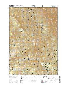
2014 Map of Big Weasel Springs
USGS Topo · Published 2014About this map
Fields Peak and the high ridges of the Aldrich Mountains dominate this central Oregon landscape within the Malhuer National Forest. The 2014 survey documents a terrain defined by complex water systems, where Murderers Cr and its tributaries like Thorn Cr and Tex Cr carve through the high country. Historical land use is evident in the network of forest development roads and the Oregon Mine Tr, which hints at the area's prospecting past near Chrome Ridge. The map is particularly notable for its numerous named water sources, including the eponymous Big Weasel Springs and several creatively named sites such as China Hat Spring and Frankie and Johnny Spring. These isolated springs and geographic landmarks like Tex Creek Arch serve as vital navigation points in this heavily forested and deeply folded mountain environment.
Find a feature on this map
53 named features on this map. Tap any name to fly to it.
Don’t see what you’re looking for? This feature index may not catch every label — zoom into the map to look around manually.
Map Details
Editions of this 2014 Big Weasel Springs Map
This is the sole edition of this map. No revisions or reprints were ever made.
Other maps of this area

1940 · Mount Vernon
USGS Topo · 1:62,500

1940 · Aldrich Mtn.
USGS Topo · 1:62,500

1943 · Aldrich Mtn.
USGS Topo · 1:62,500

1943 · Mount Vernon
USGS Topo · 1:62,500

1955 · Canyon City
USGS Topo · 1:250,000

1959 · Canyon City
USGS Topo · 1:250,000

1961 · Logdell
USGS Topo · 1:62,500

1961 · Izee
USGS Topo · 1:62,500

1972 · Big Weasel Sprs
USGS Topo · 1:24,000
1972 · Mc Clellan Mtn
USGS Topo · 1:24,000