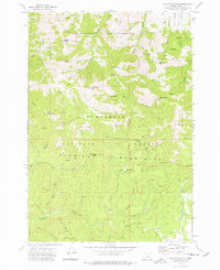
1972 Map of Mc Clellan Mtn
USGS Topo · Published 1976About this map
Aldrich Mountains peaks define this portion of the Malheur National Forest, where a network of trails and springs supported early resource extraction and land management. The presence of the Cinnabar Mine on the slopes of Cinnabar Mountain points to the area's mercury mining history, while numerous named drainages like Murderers Creek and McClellan Creek flow through the deep canyons. This 1970s survey illustrates a landscape primarily shaped by topography and water, with established routes such as the Burma Road and various pack trails providing access to high-elevation points like McClellan Mtn and Riley Mountain. The southern edge of the map transitions toward Bear Valley, showing the distinct change from the higher peaks of the Aldrich range to the valley floor. Features like Riley Creek Meadow and Packsaddle Gap highlight the traditional movement patterns through this part of the Blue Mountains region.
Find a feature on this map
46 named features on this map. Tap any name to fly to it.
Don’t see what you’re looking for? This feature index may not catch every label — zoom into the map to look around manually.
Map Details
Editions of this 1972 Mc Clellan Mtn Map
3 editions found
Other maps of this area

1940 · Mount Vernon
USGS Topo · 1:62,500

1940 · Aldrich Mtn.
USGS Topo · 1:62,500

1943 · Aldrich Mtn.
USGS Topo · 1:62,500

1943 · Mount Vernon
USGS Topo · 1:62,500

1955 · Canyon City
USGS Topo · 1:250,000

1959 · Canyon City
USGS Topo · 1:250,000

1961 · Logdell
USGS Topo · 1:62,500

1961 · Izee
USGS Topo · 1:62,500

1972 · Big Weasel Sprs
USGS Topo · 1:24,000
1972 · Mount Vernon
USGS Topo · 1:24,000