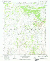
1981 Map of Big Whisker Well
USGS Topo · Published 1982About this map
The Navajo Indian Reservation landscape is defined here by the industrial presence of the Black Mesa and Lake Powell railroad, which snakes through the high desert terrain. This 1981 survey documents a region of dramatic verticality, where the prominent heights of White Mesa and the long stretch of Crooked Ridge overlook a network of four-wheel-drive tracks and isolated livestock infrastructure.
Find a feature on this map
14 named features on this map. Tap any name to fly to it.
Don’t see what you’re looking for? This feature index may not catch every label — zoom into the map to look around manually.
Map Details
Editions of this 1981 Big Whisker Well Map
This is the sole edition of this map. No revisions or reprints were ever made.
Other maps of this area

1883 · Marsh Pass
USGS Topo · 1:250,000

1886 · Echo Cliffs
USGS Topo · 1:250,000

1891 · Echo Cliffs
USGS Topo · 1:250,000

1892 · Marsh Pass
USGS Topo · 1:250,000

1956 · Marble Canyon
USGS Topo · 1:250,000

1959 · Marble Canyon
USGS Topo · 1:250,000

1961 · Marble Canyon
USGS Topo · 1:250,000

1970 · Square Butte
USGS Topo · 1:24,000
1970 · Tonalea
USGS Topo · 1:24,000
1970 · White Mesa Arch
USGS Topo · 1:24,000