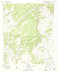
1972 Map of Big Willow Spring Canyon
USGS Topo · Published 1977About this map
Navajo Indian Reservation lands in Apache County are documented here during the early 1970s, revealing a landscape defined by critical water sources and traditional grazing infrastructure. The intricate drainages of Big Willow Spring Canyon and Beshbito Wash dominate the topography, punctuated by numerous remote water points including Sunrise Spring, Pete Spring, and the evocatively named Looking For Water Spring.
Find a feature on this map
17 named features on this map. Tap any name to fly to it.
Don’t see what you’re looking for? This feature index may not catch every label — zoom into the map to look around manually.
Map Details
Editions of this 1972 Big Willow Spring Canyon Map
This is the sole edition of this map. No revisions or reprints were ever made.
Other maps of this area

1883 · Tusayan
USGS Topo · 1:250,000

1886 · Tusayan
USGS Topo · 1:250,000

1886 · Fort Defiance
USGS Topo · 1:250,000

1892 · Fort Defiance
USGS Topo · 1:250,000

1947 · Flagstaff
USGS Topo · 1:250,000

1954 · Flagstaff
USGS Topo · 1:250,000

1954 · Gallup
USGS Topo · 1:250,000

1958 · Gallup
USGS Topo · 1:250,000

1958 · Flagstaff
USGS Topo · 1:250,000

1959 · Gallup
USGS Topo · 1:250,000
Featured Places
- Fort Defiance Agency
- Béésh Biiʼtó, Fort Defiance Agency
- Navajo County, AZ
- Apache County, AZ
- United States