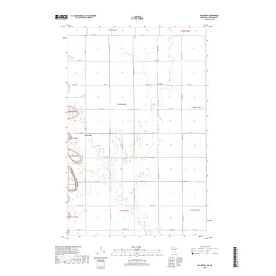
2019 Map of Big Woods
USGS Topo · Published 2019About this map
Big Woods sits at the heart of this agricultural landscape in Marshall County, defined by the winding paths of several important northern waterways. The Red River of the North forms the western boundary, separating Minnesota from North Dakota, while the Snake River and Middle River meander across the plains to the east. This region is characterized by a precise grid of rural roads, including Co Hwy 4 and Co Hwy 19, which delineate the farmsteads and fields. Local heritage is preserved at the North Big Woods Cem and Big Woods Cem, providing vital geographic anchors for genealogists tracing families in this river-border community. The map reveals the intersection of natural river dynamics and organized land division at the edge of the Red River Valley.
Find a feature on this map
25 named features on this map. Tap any name to fly to it.
Don’t see what you’re looking for? This feature index may not catch every label — zoom into the map to look around manually.
Map Details
Editions of this 2019 Big Woods Map
This is the sole edition of this map. No revisions or reprints were ever made.
Other maps of this area
1918 · Acton
USGS Topo · 1:62,500
1918 · Argyle
USGS Topo · 1:62,500
1918 · Warren
USGS Topo · 1:62,500

1952 · Thief River Falls
USGS Topo · 1:250,000
1954 · Stephen
USGS Topo · 1:62,500
1955 · Warren
USGS Topo · 1:62,500

1956 · Thief River Falls
USGS Topo · 1:250,000

1957 · Thief River Falls
USGS Topo · 1:250,000
1960 · Big Woods NW
USGS Topo · 1:24,000
1966 · Big Woods NE
USGS Topo · 1:24,000