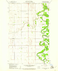
1960 Map of Big Woods NW
USGS Topo · Published 1961About this map
The Red River of the North winds in dramatic oxbows along the border of North Dakota and Minnesota, defining the eastern edge of St Andrews and Acton townships. This 1960 survey by the U.S. Geological Survey and the State of North Dakota Water Conservation Commission details a landscape shaped by water and agriculture. Small rural centers of community life are scattered throughout the grid, including St Joseph Ch and the Zion Cem, alongside numbered one-room schoolhouses like School No 87, School No 14, and School No 30. Tributaries such as the Park River and Tamarac River feed into the main channel, while the Dipple Drain illustrates early efforts at managing the flat, fertile valley floor. In the southeastern corner, Horseshoe Lake serves as a prominent example of a cutoff meander, evidence of the river's shifting path over time.
Find a feature on this map
14 named features on this map. Tap any name to fly to it.
Don’t see what you’re looking for? This feature index may not catch every label — zoom into the map to look around manually.
Map Details
Editions of this 1960 Big Woods NW Map
2 editions found
Other maps of this area

1918 · Acton
USGS Topo · 1:62,500

1939 · Drayton
USGS Topo · 1:62,500

1939 · Glasston
USGS Topo · 1:62,500

1941 · Drayton
USGS Topo · 1:62,500

1941 · Glasston
USGS Topo · 1:62,500

1943 · Grafton
USGS Topo · 1:62,500

1952 · Thief River Falls
USGS Topo · 1:250,000

1956 · Thief River Falls
USGS Topo · 1:250,000

1957 · Thief River Falls
USGS Topo · 1:250,000
1960 · Oakwood
USGS Topo · 1:24,000