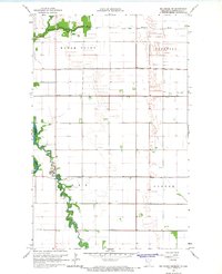
1966 Map of Big Woods NE
USGS Topo · Published 1968About this map
The Red River forms a winding border between Minnesota and North Dakota in this late-1960s survey of the Red River Valley. The landscape is defined by an extensive water management network designed for the region's flat, fertile plains, including Judicial Ditch No 9, County Ditch No 12, and Judicial Ditch No 29. These engineered waterways cut straight lines across the townships of Eagle Point, Donnelly, and Parker, contrasting with the natural meanders of the Tamarac River. A key point of interest for genealogists and local historians is the Fork Cem located near the confluence of the Snake Fork. The map illustrates a rural area dominated by agriculture and drainage projects, with only scattered structures and a prominent Radio Tower breaking the horizon.
Find a feature on this map
13 named features on this map. Tap any name to fly to it.
Don’t see what you’re looking for? This feature index may not catch every label — zoom into the map to look around manually.
Map Details
Editions of this 1966 Big Woods NE Map
This is the sole edition of this map. No revisions or reprints were ever made.
Other maps of this area

1918 · Acton
USGS Topo · 1:62,500

1918 · Argyle
USGS Topo · 1:62,500

1939 · Drayton
USGS Topo · 1:62,500

1939 · Kennedy
USGS Topo · 1:62,500

1941 · Kennedy
USGS Topo · 1:62,500

1941 · Drayton
USGS Topo · 1:62,500

1952 · Thief River Falls
USGS Topo · 1:250,000

1954 · Stephen
USGS Topo · 1:62,500

1956 · Thief River Falls
USGS Topo · 1:250,000

1957 · Thief River Falls
USGS Topo · 1:250,000