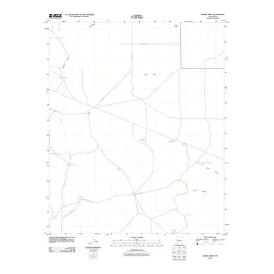
2010 Map of Bigbee Draw
USGS Topo · Published 2010About this map
White Sands Missile Range dominates the southwestern portion of this high-desert landscape, reflecting the significant military presence in this region of Socorro County during the early 21st century. The terrain is defined by the broad West Mesa and the drainage patterns of Bigbee Draw and Arroyo Seco. Because this is an arid environment, the infrastructure focuses heavily on water management for ranching and military purposes, evidenced by a network of engineered tanks such as Bigbee Tank, North Canyon Tank, and Pot Hole Tank. Human activity is sparse, centered on isolated points like Cain Ranch and the Kerr Well. The landscape is etched with utilitarian transit lines, including County RD-b006 and several restricted military routes such as WSMR S Route 3707, which cross the open desert between ephemeral water features like Brown Lake.
Find a feature on this map
27 named features on this map. Tap any name to fly to it.
Don’t see what you’re looking for? This feature index may not catch every label — zoom into the map to look around manually.
Map Details
Editions of this 2010 Bigbee Draw Map
This is the sole edition of this map. No revisions or reprints were ever made.
Other maps of this area

1954 · Socorro
USGS Topo · 1:250,000

1958 · Socorro
USGS Topo · 1:250,000

1962 · Socorro
USGS Topo · 1:250,000

1972 · Turkey Ridge
USGS Topo · 1:24,000

1972 · Gran Quivira
USGS Topo · 1:24,000
1972 · Chupadera Spring
USGS Topo · 1:24,000

1972 · Chupadera
USGS Topo · 1:24,000

1972 · Bigbee Draw
USGS Topo · 1:24,000
1972 · Turkey Ridge NE
USGS Topo · 1:24,000

1972 · Abo
USGS Topo · 1:24,000