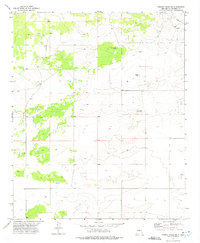
1972 Map of Turkey Ridge NE
USGS Topo · Published 1975About this map
White Lake Cem sits on a small rise above the central basin of this arid landscape in Socorro County. The terrain is defined by the intermittent waters of White Lake and the essential infrastructure of ranching and survival in the high desert, such as the North Sloan Well. This 1970s survey illustrates a region where life is oriented around scarce water sources and large-scale land divisions, marked by the intersection of Townships 1 and 2 South and Ranges 8 and 9 East. The map provides a detailed look at the scattered wells and topographic depressions that characterize this part of New Mexico, offering a clear view of the rural township grid before modern developments.
Find a feature on this map
5 named features on this map. Tap any name to fly to it.
Don’t see what you’re looking for? This feature index may not catch every label — zoom into the map to look around manually.
Map Details
Editions of this 1972 Turkey Ridge NE Map
This is the sole edition of this map. No revisions or reprints were ever made.
Other maps of this area

1954 · Fort Sumner
USGS Topo · 1:250,000

1954 · Socorro
USGS Topo · 1:250,000

1958 · Socorro
USGS Topo · 1:250,000

1958 · Fort Sumner
USGS Topo · 1:250,000

1962 · Socorro
USGS Topo · 1:250,000

1972 · Turkey Ridge
USGS Topo · 1:24,000

1972 · Turkey Ridge SW
USGS Topo · 1:24,000

1972 · Gran Quivira
USGS Topo · 1:24,000

1972 · Bigbee Draw
USGS Topo · 1:24,000
1972 · Cat Mesa
USGS Topo · 1:24,000