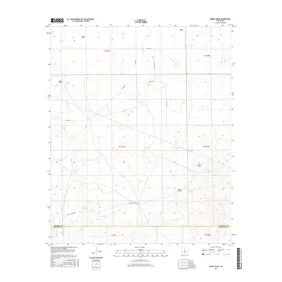
2017 Map of Bigbee Draw
USGS Topo · Published 2017About this map
Brown Lake and the eponymous Bigbee Draw anchor this high-desert landscape situated along the border of Torrance and Socorro counties. The terrain is defined by a series of drainage networks, including the prominent Arroyo Seco and the carved depressions of North Canyon and South Canyon. This area reflects the essential water management infrastructure of New Mexico's ranching and utility corridors, where numerous storage features like Bigbee Tank, Pogue Tank, and Gas Line Tank provide vital resources across the arid sections of t1n r7e and t2n r8e. Traces of human activity are concentrated along local connectors such as Painted Horse Dr and Surrey Trl, as well as established service roads like WSMR S Route 3706, illustrating the intersection of remote public lands and modern infrastructure development.
Find a feature on this map
32 named features on this map. Tap any name to fly to it.
Don’t see what you’re looking for? This feature index may not catch every label — zoom into the map to look around manually.
Map Details
Editions of this 2017 Bigbee Draw Map
This is the sole edition of this map. No revisions or reprints were ever made.
Other maps of this area

1954 · Socorro
USGS Topo · 1:250,000

1958 · Socorro
USGS Topo · 1:250,000

1962 · Socorro
USGS Topo · 1:250,000

1972 · Turkey Ridge
USGS Topo · 1:24,000

1972 · Gran Quivira
USGS Topo · 1:24,000
1972 · Chupadera Spring
USGS Topo · 1:24,000

1972 · Chupadera
USGS Topo · 1:24,000

1972 · Bigbee Draw
USGS Topo · 1:24,000
1972 · Turkey Ridge NE
USGS Topo · 1:24,000

1972 · Abo
USGS Topo · 1:24,000