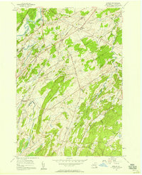
1956 Map of Bigelow
USGS Topo · Published 1958About this map
The Oswegatchie River carves through the northwestern corner of this St. Lawrence County landscape, defining a terrain of ridges and creek valleys during the mid-1950s. The New York Central Railroad corridor serves as a primary transit axis, connecting the settlements of De Kalb, East De Kalb, and Bigelow. Local life is anchored by several rural institutions, including the Acres Sch and Days Sch, along with the East De Kalb Cem and West Hermon Cem.
Find a feature on this map
37 named features on this map. Tap any name to fly to it.
Don’t see what you’re looking for? This feature index may not catch every label — zoom into the map to look around manually.
Map Details
Editions of this 1956 Bigelow Map
2 editions found
Other maps of this area

1904 · Ogdensburg
USGS Topo · 1:62,500

1905 · Ogdensburg
USGS Topo · 1:62,500

1910 · Canton
USGS Topo · 1:62,500

1911 · Canton
USGS Topo · 1:62,500

1915 · Gouverneur
USGS Topo · 1:62,500

1915 · Russell
USGS Topo · 1:62,500

1918 · Russell
USGS Topo · 1:62,500

1937 · Gouverneur
USGS Topo · 1:62,500

1943 · Rensselaer Falls
USGS Topo · 1:31,680
1943 · Heuvelton
USGS Topo · 1:31,680