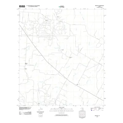
2010 Map of Bigfoot
USGS Topo · Published 2010About this map
Bigfoot and the neighboring Big Foot Colonia anchor this 2010 topographic survey of South Texas, where the landscape is defined by a network of seasonal watercourses and rural industry. The area north of town is marked by the Beer Creek Oil Field, indicating the localized energy extraction that shapes the local economy. Historical continuity is visible through the preservation of the Griffin Cemetery and Brummett Cemetery, alongside the older paths of Old Devine Rd. A web of drainage systems, including Siestedero Creek, Live Oak Creek, and Padilla Creek, carves through the terrain, leading toward southern landmarks like the Vincent Lake Dam and Kyote Lake. The presence of the Ranch-Aero Airport and the settlement of Kyote to the southeast reflects the sparse, ranch-oriented development typical of Frio County at the turn of the 21st century.
Find a feature on this map
39 named features on this map. Tap any name to fly to it.
Don’t see what you’re looking for? This feature index may not catch every label — zoom into the map to look around manually.
Map Details
Editions of this 2010 Bigfoot Map
This is the sole edition of this map. No revisions or reprints were ever made.
Other maps of this area

1934 · Schattel
USGS Topo · 1:62,500

1942 · Natalia
USGS Topo · 1:62,500

1953 · Crystal City
USGS Topo · 1:250,000

1954 · San Antonio
USGS Topo · 1:250,000

1955 · Crystal City
USGS Topo · 1:250,000

1956 · Jourdanton
USGS Topo · 1:62,500

1957 · San Antonio
USGS Topo · 1:250,000

1958 · Somerset
USGS Topo · 1:24,000

1961 · Crystal City
USGS Topo · 1:250,000

1964 · Ghost Hill
USGS Topo · 1:24,000