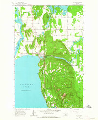
1962 Map of Bigfork
USGS Topo · Published 1964About this map
Big Fork sits at the vital junction of the Swan River and the northeast corner of Flathead Lake, showing a landscape defined by water and forest management in the early 1960s. The presence of the Big Fork Dam and the Big Fork Ranger Station highlights the community's dual role as a utility hub and a gateway to the surrounding timberlands. To the north, Echo Lake and Peterson Lake are surrounded by scattered settlements like Holt and Little Brown Ch, indicating the rural character of the Flathead Valley before significant modern development.
Find a feature on this map
27 named features on this map. Tap any name to fly to it.
Don’t see what you’re looking for? This feature index may not catch every label — zoom into the map to look around manually.
Map Details
Editions of this 1962 Bigfork Map
Other maps of this area

1914 · Nyack
USGS Topo · 1:125,000

1920 · Flathead Lake
USGS Topo · 1:125,000

1943 · Kalispell
USGS Topo · 1:125,000

1955 · Choteau
USGS Topo · 1:250,000

1956 · Wallace
USGS Topo · 1:250,000

1957 · Choteau
USGS Topo · 1:250,000

1957 · Kalispell
USGS Topo · 1:250,000

1958 · Choteau
USGS Topo · 1:250,000

1960 · Kalispell
USGS Topo · 1:250,000

1960 · Wallace
USGS Topo · 1:250,000