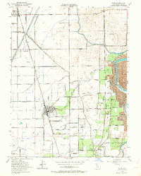
1952 Map of Biggs
USGS Topo · Published 1964About this map
Agricultural development and water management define this Central Valley landscape, centered on the city of Biggs. The region's reliance on intensive irrigation is evident in the complex network of canals and laterals, including the Cherokee Canal, Western Canal, and Main Canal. These waterways snake across the flat terrain, supported by numerous siphons, pumping stations, and windmills. To the west, the USDA Rice Experimental Sta highlights the area's specialized crop focus near Richvale. The eastern edge of the map is bounded by the Feather River, where the landscape shifts toward orchards and ranches like the Onstott Ranch and Ord Ranch. Smaller settlements such as Riceton and East Biggs are connected by a grid of named roads, many bearing family names that serve as vital clues for local genealogy. The Southern Pacific railroad corridor provides the primary industrial spine through the heart of the valley.
Find a feature on this map
52 named features on this map. Tap any name to fly to it.
Don’t see what you’re looking for? This feature index may not catch every label — zoom into the map to look around manually.
Map Details
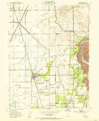
Editions of this 1952 Biggs Map
2 editions found
Other maps of this area

1888 · Marysville
USGS Topo · 1:125,000

1891 · Chico
USGS Topo · 1:125,000

1891 · Marysville
USGS Topo · 1:125,000

1893 · Chico
USGS Topo · 1:125,000

1894 · Marysville
USGS Topo · 1:125,000

1895 · Marysville
USGS Topo · 1:125,000

1895 · Chico
USGS Topo · 1:125,000

1911 · Landlow
USGS Topo · 1:31,680

1912 · Dry Creek
USGS Topo · 1:31,680

1912 · Oroville
USGS Topo · 1:31,680