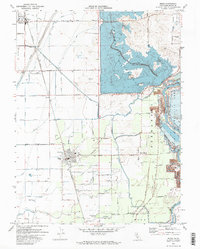
1970 Map of Biggs
USGS Topo · Published 1973About this map
Thermalito Afterbay dominates the northern landscape of this Butte County region, its artificial shoreline contrasting with the straight-line irrigation grid of the surrounding agricultural lands. The map documents an intricate water management system essential for local rice cultivation, featuring the Main Canal, East Canal, and numerous laterals such as the Burns Lateral and Ashley Lateral. The Rice Experimental Sta USDA near Riceton underscores the area's specialized farming history. In the southern half, the city of Biggs serves as a central hub, anchored by the Southern Pacific Railroad and the Union High Sch. To the east, the Feather River meanders past the Oroville Wildlife Area and through the Fernandez grant, where old river deposits are marked as Tailings, reflecting the area's intersection of hydraulic history and modern irrigation.
Find a feature on this map
76 named features on this map. Tap any name to fly to it.
Don’t see what you’re looking for? This feature index may not catch every label — zoom into the map to look around manually.
Map Details
Editions of this 1970 Biggs Map
2 editions found
Other maps of this area

1888 · Marysville
USGS Topo · 1:125,000

1891 · Chico
USGS Topo · 1:125,000

1891 · Marysville
USGS Topo · 1:125,000

1893 · Chico
USGS Topo · 1:125,000

1894 · Marysville
USGS Topo · 1:125,000

1895 · Marysville
USGS Topo · 1:125,000

1895 · Chico
USGS Topo · 1:125,000

1911 · Landlow
USGS Topo · 1:31,680

1912 · Dry Creek
USGS Topo · 1:31,680

1912 · Oroville
USGS Topo · 1:31,680