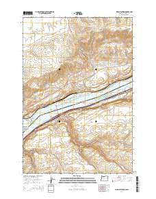
2014 Map of Biggs Junction
USGS Topo · Published 2014About this map
Lake Celilo and the Columbia River dominate this landscape at the border of Washington and Oregon, serving as the central axis for regional transit and water management. On the Washington side, the settlement of Maryhill sits below the Columbia Hills, near landmarks such as Stonehenge Dr and the Sam Hill Memorial Bridge. Across the water in Oregon, the junctions at Biggs Junction and the town of Rufus represent critical nodes for highway and river commerce. The terrain is defined by dramatic elevation changes, from the river level up through Spanish Hollow and Davies Pass, while the southern reaches of the map reveal deep drainages like China Hollow and Mud Hollow. Small water bodies such as McCarty Pond and Wheelhouse Pond dot the northern slopes, providing contrast to the massive scale of the river channel and the nearby Gifford Pinchot National Forest.
Find a feature on this map
52 named features on this map. Tap any name to fly to it.
Don’t see what you’re looking for? This feature index may not catch every label — zoom into the map to look around manually.
Map Details
Editions of this 2014 Biggs Junction Map
This is the sole edition of this map. No revisions or reprints were ever made.
Other maps of this area

1953 · The Dalles
USGS Topo · 1:250,000

1956 · The Dalles
USGS Topo · 1:250,000

1957 · The Dalles
USGS Topo · 1:250,000

1957 · Wasco
USGS Topo · 1:62,500

1957 · Goldendale
USGS Topo · 1:62,500

1957 · Wishram
USGS Topo · 1:62,500

1957 · Satus Pass
USGS Topo · 1:62,500

1971 · Rufus
USGS Topo · 1:24,000
1971 · Wasco
USGS Topo · 1:24,000
1974 · Locust Grove
USGS Topo · 1:24,000