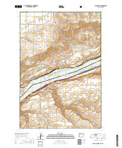
2020 Map of Biggs Junction
USGS Topo · Published 2020About this map
Lake Celilo and the mighty river corridor dominate this landscape, where the modern interstate and rail networks converge at Biggs Junction. The terrain transitions sharply from the elevated Columbia Hills in the north down to the water's edge, linked by the Sam Hill Memorial Bridge. This 2020 survey reveals the complex infrastructure supporting regional transit, including the Hells Gate Channel Range B navigation markers and several major highways. On the northern banks, the settlement of Maryhill sits near distinctive landmarks like Stonehenge Dr, while the southern side features the town of Rufus and the rail siding at Thornberry. The map details numerous canyons and hollows, such as China Hollow and Spanish Hollow, which cut through the high plateau, illustrating how geography has dictated the placement of roads like the Maryhill Hwy and the Biggs Rufus Hwy.
Find a feature on this map
56 named features on this map. Tap any name to fly to it.
Don’t see what you’re looking for? This feature index may not catch every label — zoom into the map to look around manually.
Map Details
Editions of this 2020 Biggs Junction Map
This is the sole edition of this map. No revisions or reprints were ever made.
Other maps of this area

1953 · The Dalles
USGS Topo · 1:250,000

1956 · The Dalles
USGS Topo · 1:250,000

1957 · The Dalles
USGS Topo · 1:250,000

1957 · Wasco
USGS Topo · 1:62,500

1957 · Goldendale
USGS Topo · 1:62,500

1957 · Wishram
USGS Topo · 1:62,500

1957 · Satus Pass
USGS Topo · 1:62,500

1971 · Rufus
USGS Topo · 1:24,000
1971 · Wasco
USGS Topo · 1:24,000
1974 · Locust Grove
USGS Topo · 1:24,000