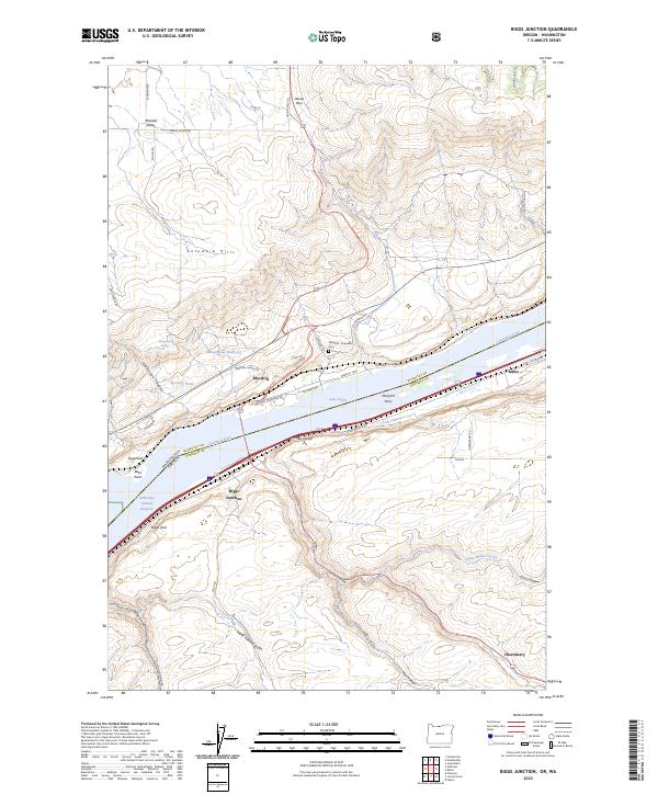
2023 Map of Biggs Junction
USGS Topo · Published 2023About this map
Lake Celilo and the Columbia River dominate this modern geographic study of the border between Oregon and Washington. The landscape is defined by the steep, dramatic basalt formations of the Columbia Hills to the north and the complex drainage systems of Spanish Hollow, Mud Hollow, and Frank Fulton Canyon to the south. Historically significant transportation and settlement patterns are visible at Biggs Junction and Maryhill, where the Maryhill Ferry crossing and Maryhill - Columbus Cem anchor the local history.
Find a feature on this map
56 named features on this map. Tap any name to fly to it.
Don’t see what you’re looking for? This feature index may not catch every label — zoom into the map to look around manually.
Map Details
Editions of this 2023 Biggs Junction Map
This is the sole edition of this map. No revisions or reprints were ever made.
Other maps of this area

1953 · The Dalles
USGS Topo · 1:250,000

1956 · The Dalles
USGS Topo · 1:250,000

1957 · The Dalles
USGS Topo · 1:250,000

1957 · Wasco
USGS Topo · 1:62,500

1957 · Goldendale
USGS Topo · 1:62,500

1957 · Wishram
USGS Topo · 1:62,500

1957 · Satus Pass
USGS Topo · 1:62,500

1971 · Rufus
USGS Topo · 1:24,000
1971 · Wasco
USGS Topo · 1:24,000
1974 · Locust Grove
USGS Topo · 1:24,000