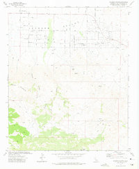
1972 Map of Bighorn Canyon
USGS Topo · Published 1975About this map
Johnson Valley provides a clear look at the high desert interface between organized road grids and the rising foothills of the Bighorn Mountains in the early 1970s. The northern portion of the map shows an emerging network of planned residential streets with botanical names like Joshua Tree Avenue, Manzanita Ave, and Quailbush Avenue. This geometry dissolves into the winding topography of the south, where Bighorn Canyon and Ruby Canyon dominate the landscape.
Find a feature on this map
31 named features on this map. Tap any name to fly to it.
Don’t see what you’re looking for? This feature index may not catch every label — zoom into the map to look around manually.
Map Details
Editions of this 1972 Bighorn Canyon Map
3 editions found
Other maps of this area

1901 · Southern California Sheet No. 1
USGS Topo · 1:250,000

1902 · San Gorgonio
USGS Topo · 1:125,000

1904 · Southern California Sheet No. 1
USGS Topo · 1:250,000

1953 · San Bernardino
USGS Topo · 1:250,000

1954 · Emerson Lake
USGS Topo · 1:24,000

1955 · Old Woman Springs
USGS Topo · 1:62,500

1955 · Emerson Lake
USGS Topo · 1:62,500

1955 · Morongo Valley
USGS Topo · 1:62,500

1955 · Joshua Tree
USGS Topo · 1:62,500

1956 · San Bernardino
USGS Topo · 1:250,000