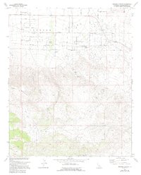
1972 Map of Bighorn Canyon
USGS Topo · Published 1994About this map
Johnson Valley defines the northern half of this desert landscape, characterized by a grid of namesake roads such as Joshua Tree Avenue, Datura Avenue, and Saddlerock Avenue. The map captures the area's transition from high-desert plateaus to the prominent Bighorn Mountains, where drainage patterns like Bighorn Canyon and Ruby Canyon cut deep into the terrain. Human presence in this arid region is marked by utilitarian infrastructure, including a Landing Strip and a secondary Landing Field, along with scattered resources like a Water Tank, several Cistern points, and the Rock Corral. At the southern edge, the Parsons Ranch and Well locations indicate the small-scale agricultural and ranching efforts that sought to utilize the sparse water supply in this corner of San Bernardino County.
Find a feature on this map
34 named features on this map. Tap any name to fly to it.
Don’t see what you’re looking for? This feature index may not catch every label — zoom into the map to look around manually.
Map Details
Editions of this 1972 Bighorn Canyon Map
3 editions found
Other maps of this area

1901 · Southern California Sheet No. 1
USGS Topo · 1:250,000

1902 · San Gorgonio
USGS Topo · 1:125,000

1904 · Southern California Sheet No. 1
USGS Topo · 1:250,000

1953 · San Bernardino
USGS Topo · 1:250,000

1954 · Emerson Lake
USGS Topo · 1:24,000

1955 · Old Woman Springs
USGS Topo · 1:62,500

1955 · Emerson Lake
USGS Topo · 1:62,500

1955 · Morongo Valley
USGS Topo · 1:62,500

1955 · Joshua Tree
USGS Topo · 1:62,500

1956 · San Bernardino
USGS Topo · 1:250,000