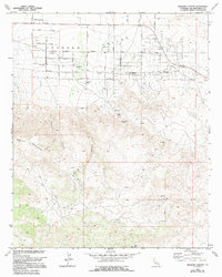
1972 Map of Bighorn Canyon
USGS Topo · Published 1994About this map
Johnson Valley stretches across the northern portion of this map, characterized by a systematic grid of residential and arterial roads named for desert flora, including Joshua Tree Avenue, Manzanita Ave, and Cholla Avenue. This desert community development contrasts sharply with the southern terrain, where the Bighorn Mountains rise abruptly. The landscape here is carved by significant drainage systems such as Bighorn Canyon and Ruby Canyon, which served as natural corridors through the high country. In the far southwest, the settlement of Meeks sits near the higher peaks, while markers like Rock Corral and various scattered Cisterns and Springs indicate the critical importance of water management in this arid environment. The map also documents early aviation infrastructure with a Landing Strip and a dedicated Landing Field positioned to serve the valley's residents.
Find a feature on this map
53 named features on this map. Tap any name to fly to it.
Don’t see what you’re looking for? This feature index may not catch every label — zoom into the map to look around manually.
Map Details
Editions of this 1972 Bighorn Canyon Map
3 editions found
Other maps of this area

1901 · Southern California Sheet No. 1
USGS Topo · 1:250,000

1902 · San Gorgonio
USGS Topo · 1:125,000

1904 · Southern California Sheet No. 1
USGS Topo · 1:250,000

1953 · San Bernardino
USGS Topo · 1:250,000

1954 · Emerson Lake
USGS Topo · 1:24,000

1955 · Old Woman Springs
USGS Topo · 1:62,500

1955 · Emerson Lake
USGS Topo · 1:62,500

1955 · Morongo Valley
USGS Topo · 1:62,500

1955 · Joshua Tree
USGS Topo · 1:62,500

1956 · San Bernardino
USGS Topo · 1:250,000