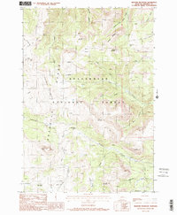
1988 Map of Bighorn Mountain
USGS Topo · Published 1988About this map
The Beaverhead National Forest defines this high-elevation landscape in Madison County, where the steep terrain of the Gravelly Range meets the drainage of the South Fork Ruby Creek. Evidence of local ranching and land management is visible through markers like the Redish Sheep Headquarters and Black Butte Cabin, reflecting the area's history of seasonal grazing and forest service operations. The map documents a complex network of peaks and ridges, including Bighorn Mountain and Lion Mountain, which provide the backdrop for numerous water sources such as Wall Creek Lake and Kelly Reservoir. Transportation through this wilderness is facilitated by high-ridgeline routes like the Gravelly Range Road and the Standard Creek Road, which follow the natural contours of the land to reach significant landmarks like Specimen Butte and Cave Mountain.
Find a feature on this map
36 named features on this map. Tap any name to fly to it.
Don’t see what you’re looking for? This feature index may not catch every label — zoom into the map to look around manually.
Map Details
Editions of this 1988 Bighorn Mountain Map
2 editions found
Other maps of this area

1888 · Three Forks
USGS Topo · 1:250,000

1894 · Three Forks
USGS Topo · 1:250,000

1895 · Three Forks
USGS Topo · 1:250,000

1947 · Bozeman
USGS Topo · 1:250,000

1948 · Bozeman
USGS Topo · 1:250,000

1949 · Varney
USGS Topo · 1:62,500

1950 · Cliff Lake
USGS Topo · 1:62,500

1950 · Cameron
USGS Topo · 1:62,500

1950 · Monument Ridge
USGS Topo · 1:62,500

1955 · Bozeman
USGS Topo · 1:250,000