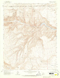
1963 Map of Bighorn Peak
USGS Topo · Published 1967About this map
Bighorn Peak stands as a prominent landmark at the intersection of the Rio Grande National Forest and Carson National Forest, marking a landscape defined by the drainage basins of northern New Mexico and southern Colorado. This 1963 field-checked survey highlights the high-altitude transit routes of the era, most notably the Rio Grande and Western railroad corridor which winds near the northern boundary through Sublette. The map captures the complex network of deep canyons and watercourses that shape the terrain, including the Rio de los Pinos and Rio San Antonio. Human activity is marked by small settlements like San Miguel, scattered springs, and a remote Cem (cemetery), while various pack trails and jeep trails suggest the region's historical reliance on seasonal access. The presence of China Dry Lake and the Banco Julian provides further geographic context for researchers studying the diverse landforms of the Rio Arriba area during the mid-twentieth century.
Find a feature on this map
30 named features on this map. Tap any name to fly to it.
Don’t see what you’re looking for? This feature index may not catch every label — zoom into the map to look around manually.
Map Details
Editions of this 1963 Bighorn Peak Map
2 editions found
Other maps of this area

1918 · Tusas
USGS Topo · 1:125,000

1922 · Conejos
USGS Topo · 1:125,000

1945 · Durango
USGS Topo · 1:250,000

1953 · Durango
USGS Topo · 1:250,000

1954 · Durango
USGS Topo · 1:250,000

1954 · Aztec
USGS Topo · 1:250,000

1955 · Brazos Peak
USGS Topo · 1:62,500

1958 · Aztec
USGS Topo · 1:250,000

1961 · Durango
USGS Topo · 1:250,000

1962 · Aztec
USGS Topo · 1:250,000