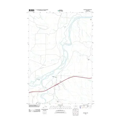
2011 Map of Bighorn
USGS Topo · Published 2011About this map
The confluence of the Bighorn River and the Yellowstone River anchors this landscape in Treasure County, Montana. The small settlement of Bighorn, identified by its local landmark the Bighorn Post Office, sits near the southern bank where the valley widens. Historically significant sites like Fort Pease are situated north of the river, while the complex riparian environment is further defined by Government Island. This 2011 survey details an intricate irrigation network essential to the region's agricultural character, featuring the Bighorn Tullock Ditch and Victory Ditch. The terrain is marked by numerous named coulees, such as Pasco Coulee and Petes Coulee, and elevated overlooks like Guys Bluffs. Local transportation is traced through a system of secondary roads including Pease Bottom Rd and Meyers Rd, providing access to the various forks of Edwards Creek and Fortysix Creek that drain into the main river systems.
Find a feature on this map
31 named features on this map. Tap any name to fly to it.
Don’t see what you’re looking for? This feature index may not catch every label — zoom into the map to look around manually.
Map Details
Editions of this 2011 Bighorn Map
This is the sole edition of this map. No revisions or reprints were ever made.
Other maps of this area

1954 · Forsyth
USGS Topo · 1:250,000

1957 · Forsyth
USGS Topo · 1:250,000

1958 · Forsyth
USGS Topo · 1:250,000

1960 · Bighorn
USGS Topo · 1:24,000

1960 · Custer
USGS Topo · 1:24,000

1960 · Myers
USGS Topo · 1:24,000

1960 · Rancher Cemetery
USGS Topo · 1:24,000

1960 · Marsh Coulee
USGS Topo · 1:24,000
1960 · Mission Creek
USGS Topo · 1:24,000

1960 · Eldering Ranch
USGS Topo · 1:24,000