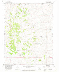
1970 Map of Bijou
USGS Topo · Published 1973About this map
Middle Bijou Creek and its complex system of tributary gulches define the landscape of Elbert County in the early 1970s. The terrain is marked by a network of drainage features including Hay Gulch, Willow Gulch, and Mule Gulch, illustrating the erosional patterns of the High Plains. Transportation in this era relied on established routes like Ridge Road, which follows the high ground between watersheds.
Find a feature on this map
14 named features on this map. Tap any name to fly to it.
Don’t see what you’re looking for? This feature index may not catch every label — zoom into the map to look around manually.
Map Details
Editions of this 1970 Bijou Map
4 editions found
Other maps of this area

1953 · Denver
USGS Topo · 1:250,000

1957 · Denver
USGS Topo · 1:250,000

1958 · Denver
USGS Topo · 1:250,000

1960 · Denver
USGS Topo · 1:250,000

1968 · Deer Trail
USGS Topo · 1:24,000
1969 · Strasburg SE
USGS Topo · 1:24,000
1969 · Deer Trail
USGS Topo · 1:24,000
1969 · Byers SW
USGS Topo · 1:24,000
1970 · Kiowa NE
USGS Topo · 1:24,000

1970 · Big Gulch
USGS Topo · 1:24,000