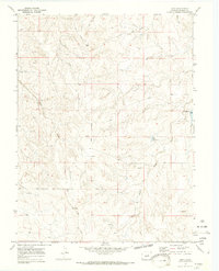
1970 Map of Bijou
USGS Topo · Published 1973About this map
Middle Bijou Creek carves a path through the rolling geography of Elbert County, defining the drainage patterns and land use in this section of the High Plains. Photogrammetric methods from 1968 aerial imagery show a landscape organized around central ridges and long drainage gulches, including Mule Gulch and East Gulch. The presence of the Gair Cem provides a specific point of interest for genealogists tracing local families in this sparsely settled area. Human infrastructure is subtly marked by the winding Ridge Road and a utility Pipeline crossing the northern terrain. The map also identifies several Gravel Pits, indicating localized resource extraction alongside the primary ranching or agricultural use of the land. Blue-tinted areas along the creek beds, marked as subject to controlled inundation, highlight the water management efforts near the Spillway and Riser structures.
Find a feature on this map
14 named features on this map. Tap any name to fly to it.
Don’t see what you’re looking for? This feature index may not catch every label — zoom into the map to look around manually.
Map Details
Editions of this 1970 Bijou Map
4 editions found
Other maps of this area

1953 · Denver
USGS Topo · 1:250,000

1957 · Denver
USGS Topo · 1:250,000

1958 · Denver
USGS Topo · 1:250,000

1960 · Denver
USGS Topo · 1:250,000

1968 · Deer Trail
USGS Topo · 1:24,000
1969 · Strasburg SE
USGS Topo · 1:24,000
1969 · Deer Trail
USGS Topo · 1:24,000
1969 · Byers SW
USGS Topo · 1:24,000
1970 · Kiowa NE
USGS Topo · 1:24,000

1970 · Big Gulch
USGS Topo · 1:24,000