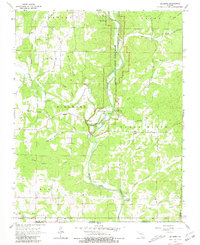
1966 Map of Billmore
USGS Topo · Published 1981About this map
The Eleven Point National Scenic River carves a deep path through the Ozark landscape of southern Missouri in this mid-1960s survey. The river's serpentine course is defined by its many water sources, including Blue Spring, Sullivan Spring, and Vault Spring, particularly concentrated around the geological feature known as The Narrows. This area shows a sparse but established rural settlement pattern, anchored by the community of Billmore and the crossroads at Calm.
Find a feature on this map
56 named features on this map. Tap any name to fly to it.
Don’t see what you’re looking for? This feature index may not catch every label — zoom into the map to look around manually.
Map Details
Editions of this 1966 Billmore Map
2 editions found
Other maps of this area

1941 · Gatewood
USGS Topo · 1:62,500

1944 · Couch
USGS Topo · 1:62,500

1945 · Gatewood
USGS Topo · 1:62,500

1946 · Couch
USGS Topo · 1:62,500

1957 · Poplar Bluff
USGS Topo · 1:250,000

1959 · Poplar Bluff
USGS Topo · 1:250,000

1960 · Poplar Bluff
USGS Topo · 1:250,000
1965 · Riverton
USGS Topo · 1:24,000

1965 · Gatewood
USGS Topo · 1:24,000
1965 · Bardley
USGS Topo · 1:24,000