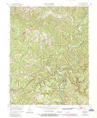
1952 Map of Billows
USGS Topo · Published 1987About this map
The Rockcastle River carves a deep path through this 1952 landscape, marking the rugged boundary between Rockcastle, Pulaski, and Laurel counties. This survey, photorevised in 1987, reveals a rural network of small settlements and neighborhood institutions within the Cumberland National Forest. Local life is anchored by a significant number of rural schoolhouses, including Gum Springs Sch and Whitaker Sch, alongside centers like Walnut Grove Ch.
Find a feature on this map
44 named features on this map. Tap any name to fly to it.
Don’t see what you’re looking for? This feature index may not catch every label — zoom into the map to look around manually.
Map Details
Editions of this 1952 Billows Map
3 editions found
Other maps of this area

1893 · London
USGS Topo · 1:125,000

1897 · London
USGS Topo · 1:125,000

1952 · London SW
USGS Topo · 1:24,000

1952 · Billows
USGS Topo · 1:24,000

1952 · Ano
USGS Topo · 1:24,000

1952 · Dykes
USGS Topo · 1:24,000

1952 · Shopville
USGS Topo · 1:24,000

1952 · Bernstadt
USGS Topo · 1:24,000

1953 · Maretburg
USGS Topo · 1:24,000

1953 · Livingston
USGS Topo · 1:24,000