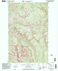
2002 Map of Billy Goat Mountain
USGS Topo · Published 2006About this map
The Pasayten Wilderness dominates this corner of the Okanogan National Forest, where the high peaks of the North Cascades meet the drainage systems of the Okanogan. At the center of the sheet, the Billy Goat Mine sits near the headwaters of Eightmile Creek, an indicator of early prospecting efforts in this high-altitude terrain. The map documents a network of passes and ridgelines, including Three Fools Pass and Isabella Ridge, which served as critical navigation points for early travelers and forest rangers.
Find a feature on this map
35 named features on this map. Tap any name to fly to it.
Don’t see what you’re looking for? This feature index may not catch every label — zoom into the map to look around manually.
Map Details
Editions of this 2002 Billy Goat Mountain Map
This is the sole edition of this map. No revisions or reprints were ever made.
Other maps of this area

1955 · Concrete
USGS Topo · 1:250,000

1958 · Concrete
USGS Topo · 1:250,000

1962 · Concrete
USGS Topo · 1:250,000

1962 · Mazama
USGS Topo · 1:62,500

1963 · Doe Mountain
USGS Topo · 1:62,500

1969 · Mt. Barney
USGS Topo · 1:24,000

1969 · Lost Peak
USGS Topo · 1:24,000

1969 · Remmel Mtn.
USGS Topo · 1:24,000
1969 · Ashnola Mtn
USGS Topo · 1:24,000

1969 · Billy Goat Mtn
USGS Topo · 1:24,000