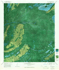
1966 Map of Billys Island
USGS Topo · Published 1967About this map
Billys Island stands as a significant terrestrial landmark within the expansive marshlands of the Okefenokee National Wildlife Refuge. This controlled photomosaic, an experimental edition for its time, reveals the complex intersection of natural swamp ecology and human history. Relics of a bygone timber industry are visible in the form of a Dismantled Logging Tram cutting across Jackson Bay, tracing the routes used to harvest the region's cypress and pine.
Find a feature on this map
24 named features on this map. Tap any name to fly to it.
Don’t see what you’re looking for? This feature index may not catch every label — zoom into the map to look around manually.
Map Details
Editions of this 1966 Billys Island Map
2 editions found
Other maps of this area

1918 · Folkston
USGS Topo · 1:62,500

1918 · Moniac
USGS Topo · 1:62,500

1942 · Moniac
USGS Topo · 1:62,500

1954 · Valdosta
USGS Topo · 1:250,000

1958 · Valdosta
USGS Topo · 1:250,000

1959 · Valdosta
USGS Topo · 1:250,000

1965 · Chesser Island
USGS Topo · 1:24,000

1965 · Double Lakes
USGS Topo · 1:24,000

1965 · Chase Prairie
USGS Topo · 1:24,000

1965 · Blackjack Island
USGS Topo · 1:24,000