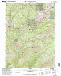
1998 Map of Billys Peak
USGS Topo · Published 2003About this map
The high alpine terrain of the Scott Mountains dominates this late-twentieth-century survey, revealing a landscape defined by its mining history and expansive wilderness areas. Mineral exploration is well-documented through sites like the Lotus Mine and Klatt Mine in the north, while the southern reaches near Billys Peak feature the Gypsy Queen Mine and Mary Queen Mine. These operations, along with various named adits and prospects, suggest a legacy of hard-rock mining tucked into the steep drainages of the North Fork Coffee Creek.
Find a feature on this map
56 named features on this map. Tap any name to fly to it.
Don’t see what you’re looking for? This feature index may not catch every label — zoom into the map to look around manually.
Map Details
Editions of this 1998 Billys Peak Map
This is the sole edition of this map. No revisions or reprints were ever made.
Other maps of this area

1886 · Shasta
USGS Topo · 1:250,000

1894 · Shasta
USGS Topo · 1:250,000

1923 · Sawyers Bar
USGS Topo · 1:125,000

1931 · Etna
USGS Topo · 1:96,000

1934 · Etna
USGS Topo · 1:125,000

1948 · Weed
USGS Topo · 1:250,000

1950 · Weed
USGS Topo · 1:250,000
1955 · Bonanza King
USGS Topo · 1:62,500
1955 · China Mountain
USGS Topo · 1:62,500

1955 · Etna
USGS Topo · 1:62,500