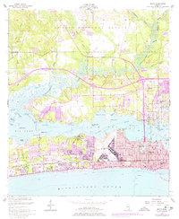
1954 Map of Biloxi
USGS Topo · Published 1978About this map
Keesler Air Force Base dominates the eastern peninsula of this coastal landscape, situated between the Back Bay of Biloxi and the Mississippi Sound. The mid-century urban development of Biloxi is clearly contrasted against the marshes and inlets to the west, where Big Lake and the Tchoutacabouffa River define the local hydrography. Significant institutional landmarks are present, including the Veterans Administration Center and the Beauvoir estate, alongside local education centers like Notre Dame High Sch and Central High Sch.
Find a feature on this map
67 named features on this map. Tap any name to fly to it.
Don’t see what you’re looking for? This feature index may not catch every label — zoom into the map to look around manually.
Map Details
Editions of this 1954 Biloxi Map
5 editions found
Other maps of this area

1953 · Mobile
USGS Topo · 1:250,000

1954 · Vestry
USGS Topo · 1:62,500

1954 · McHenry
USGS Topo · 1:62,500

1954 · Gulfport North
USGS Topo · 1:24,000

1954 · Gulfport South
USGS Topo · 1:24,000

1954 · Ocean Springs
USGS Topo · 1:24,000

1954 · Biloxi
USGS Topo · 1:24,000

1954 · Deer Island
USGS Topo · 1:24,000

1954 · Biloxi
USGS Topo · 1:62,500

1957 · Mobile
USGS Topo · 1:250,000