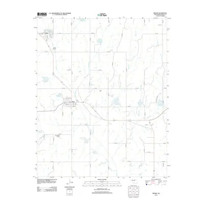
2012 Map of Binger
USGS Topo · Published 2012About this map
Binger and Lookeba anchor this Caddo County landscape, which is defined by an extensive network of water management sites along the drainages of Sugar Cr and its tributaries. The map details a rural infrastructure of numerous small reservoirs, such as Sugar Cr Site 24 Reservoir and Sugar Cr Site 6 Reservoir, which dot the terrain between the local creek systems of Medicine Cr and Kickapoo Cr. These engineered features contrast with the natural topography of Devils Canyon and Horseshoe Canyon, providing a clear look at the region's 21st-century hydrological development. Genealogists will find exact locations for the Binger Cem and Scott Cem, while the detailed street grids for the primary settlements show the layout of residential roads like Cottonwood St and Wichita Ave.
Find a feature on this map
55 named features on this map. Tap any name to fly to it.
Don’t see what you’re looking for? This feature index may not catch every label — zoom into the map to look around manually.
Map Details
Editions of this 2012 Binger Map
This is the sole edition of this map. No revisions or reprints were ever made.
Other maps of this area

1893 · Buggy Creek
USGS Topo · 1:62,500

1945 · Anadarko
USGS Topo · 1:62,500

1951 · Binger
USGS Topo · 1:62,500

1951 · Fort Cobb
USGS Topo · 1:62,500

1955 · Clinton
USGS Topo · 1:250,000

1957 · Clinton
USGS Topo · 1:250,000
1967 · Cogar
USGS Topo · 1:24,000
1967 · Cogar NW
USGS Topo · 1:24,000
1968 · Anadarko NW
USGS Topo · 1:24,000

1979 · Hinton
USGS Topo · 1:24,000