
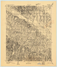
1893 Map of Buggy Creek
USGS Topo · Published 1893About this map
The Wichita Reservation dominates this 1893 landscape, characterized by the intricate drainage systems that feed into the Canadian River. Surveyed by H.B. Blair under the direction of J.W. Powell, the map captures a pivotal moment in the territory's history just as formal county boundaries were being established. The presence of an Indian Village and a Stage Stand near the river suggests a corridor of movement and transition along the Canadian Co. Boundary Line. The terrain is defined by deeply eroded creek beds, including Buggy Creek and Face Creek, which create a complex network of ridges and ravines typical of the region before modern development. This advance sheet serves as a primary record of pre-statehood topography, documenting the interaction between Indigenous lands and the encroaching administrative structures of the late nineteenth century.
Find a feature on this map
7 named features on this map. Tap any name to fly to it.
Don’t see what you’re looking for? This feature index may not catch every label — zoom into the map to look around manually.
Map Details
Editions of this 1893 Buggy Creek Map
2 editions found
Other maps of this area

1892 · Kingfisher
USGS Topo · 1:125,000

1893 · Fort Reno
USGS Topo · 1:62,500

1893 · Minco
USGS Topo · 1:62,500

1895 · Kingfisher
USGS Topo · 1:125,000

1904 · Chickasha
USGS Topo · 1:125,000

1941 · Fort Reno
USGS Topo · 1:62,500

1942 · Fort Reno
USGS Topo · 1:62,500

1942 · Geary
USGS Topo · 1:62,500

1945 · Anadarko
USGS Topo · 1:62,500

1949 · Fort Reno
USGS Topo · 1:62,500