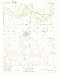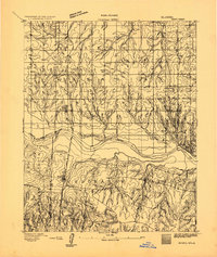
1893 Map of Minco
USGS Topo · Published 1893About this map
Chickasaw Nation lands meet the Oklahoma Indian Territory along the southern banks of the Canadian River in this late 19th-century survey. The landscape is defined by the sharp transition between the river lowlands and the dissected uplands to the south, where Buggy Creek and Stork Creek carve into the territory. This era represents a critical juncture for the region, as the Chicago Rock Island and Pacific Rail Road provided a vital north-south link through Minco, facilitating the movement of goods and people across these tribal boundaries. Small agrarian settlements like Union, Liberty, and Thurston are plotted among the township grids, showing the early stages of non-native encroachment and organized settlement before Oklahoma's statehood. The detailed topographic work of H.B. Blair and G.T. Hawkins captures the complex drainage patterns and established territorial lines that would soon be reshaped by the coming decades of development.
Find a feature on this map
17 named features on this map. Tap any name to fly to it.
Don’t see what you’re looking for? This feature index may not catch every label — zoom into the map to look around manually.
Map Details
Editions of this 1893 Minco Map
This is the sole edition of this map. No revisions or reprints were ever made.
Historical Maps of Oklahoma City Through Time
7 maps found