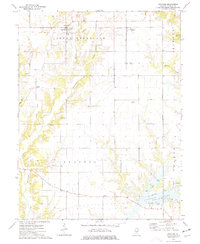
1974 Map of Bingham
USGS Topo · Published 1977About this map
The Norfolk and Western railway corridor defines the northern landscape of this Fayette County survey, connecting the small settlements of Bingham and Bayle City. This rural area is marked by a dense concentration of historical burial grounds, including the Browning, Cook, and Isbell cemeteries, which offer valuable data points for local genealogy. To the south, the terrain shifts towards the recreational waters of Vandalia Lake, featuring a Campground and multiple Boat Ramps. The survey meticulously documents the rural social fabric of the 1970s, anchoring the community with landmarks like Canaan Ch and Bethel Ch. Notable geographic features such as Hurricane Creek and Bear Creek carve through the townships, while a prominent Pipeline and the Third Principal Meridian serve as significant man-made and legal markers across the Illinois countryside.
Find a feature on this map
34 named features on this map. Tap any name to fly to it.
Don’t see what you’re looking for? This feature index may not catch every label — zoom into the map to look around manually.
Map Details
Editions of this 1974 Bingham Map
This is the sole edition of this map. No revisions or reprints were ever made.
Other maps of this area

1932 · Greenville
USGS Topo · 1:62,500

1939 · Greenville
USGS Topo · 1:62,500

1943 · Greenville
USGS Topo · 1:62,500

1944 · Ramsey
USGS Topo · 1:62,500

1945 · Vandalia
USGS Topo · 1:62,500

1946 · Ramsey
USGS Topo · 1:62,500

1947 · Vandalia
USGS Topo · 1:62,500

1947 · Hillsboro
USGS Topo · 1:62,500

1949 · Hillsboro
USGS Topo · 1:62,500

1958 · Decatur
USGS Topo · 1:250,000