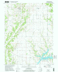
1998 Map of Bingham
USGS Topo · Published 2002About this map
Bingham serves as the quiet center of this Fayette County landscape, where the agricultural grid of South Hurricane and Shafter townships meets the winding drainages of Hurricane Creek. The map reveals a high concentration of historic burial grounds scattered across the countryside, including the Browning Cem and Rush Cem, reflecting generations of rural settlement. In the south, the terrain transforms at Vandalia Lake, a significant water body featuring a Boat Ramp and Campground that mark it as a local recreational hub. The western boundary is defined by the Third Principal Meridian, a critical surveying line that dictated the geometric layout of Illinois. Settlements like Bayle City (Bayle) and Shafter anchor the rural road network, while landmarks like the Radio Facility and Bethel Ch provide points of orientation within the open prairie and creek bottoms.
Find a feature on this map
30 named features on this map. Tap any name to fly to it.
Don’t see what you’re looking for? This feature index may not catch every label — zoom into the map to look around manually.
Map Details
Editions of this 1998 Bingham Map
This is the sole edition of this map. No revisions or reprints were ever made.
Other maps of this area

1932 · Greenville
USGS Topo · 1:62,500

1939 · Greenville
USGS Topo · 1:62,500

1943 · Greenville
USGS Topo · 1:62,500

1944 · Ramsey
USGS Topo · 1:62,500

1945 · Vandalia
USGS Topo · 1:62,500

1946 · Ramsey
USGS Topo · 1:62,500

1947 · Vandalia
USGS Topo · 1:62,500

1947 · Hillsboro
USGS Topo · 1:62,500

1949 · Hillsboro
USGS Topo · 1:62,500

1958 · Decatur
USGS Topo · 1:250,000