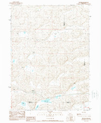
1989 Map of Bingham
USGS Topo · Published 1989About this map
The settlement of Bingham serves as the central hub for this late twentieth-century landscape, situated at the convergence of four distinct Nebraska counties. The terrain is defined by its ranching history and a complex network of wetlands and depressions typical of the Sandhills region. Large family-run operations, including the Sellers Ranch, Finnegan Ranch, and Edmondson Ranch, are scattered across the sheet, reflecting a land use pattern dominated by livestock and wide-open spaces.
Find a feature on this map
17 named features on this map. Tap any name to fly to it.
Don’t see what you’re looking for? This feature index may not catch every label — zoom into the map to look around manually.
Map Details
Editions of this 1989 Bingham Map
This is the sole edition of this map. No revisions or reprints were ever made.
Other maps of this area

1948 · Ashby
USGS Topo · 1:62,500

1948 · Bingham
USGS Topo · 1:62,500

1948 · George Lake
USGS Topo · 1:62,500

1949 · Ashby
USGS Topo · 1:62,500

1950 · George Lake
USGS Topo · 1:62,500

1950 · Longfellow Lake
USGS Topo · 1:62,500

1950 · Bingham
USGS Topo · 1:62,500

1954 · Scottsbluff
USGS Topo · 1:250,000

1954 · North Platte
USGS Topo · 1:250,000

1955 · Alliance
USGS Topo · 1:250,000