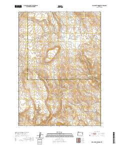
2020 Map of Birch Creek Meadow
USGS Topo · Published 2020About this map
Birch Creek Meadow lies along the transition between the high desert of Malheur and Baker Counties in eastern Oregon. This 2020 topographical survey reveals a landscape deeply carved by drainage systems, including Whisky Gulch, Deer Gulch, and Dry Gulch, which feed into the area's primary waterways like Birch Cr and Durbin Cr. Water management is central to the land's utility, evidenced by the series of three Kivett Reservoirs and numerous natural sources such as Falkner Spring, Cottonwood Spring, and Cherry Spring. Limited road access via Huntington Rd and Malheur Reservoir Rd underscores the territory's use for ranching and resource extraction, anchored by landmarks like Limestone Butte and the descriptive Stone Quarry Gulch.
Find a feature on this map
31 named features on this map. Tap any name to fly to it.
Don’t see what you’re looking for? This feature index may not catch every label — zoom into the map to look around manually.
Map Details
Editions of this 2020 Birch Creek Meadow Map
This is the sole edition of this map. No revisions or reprints were ever made.
Other maps of this area

1950 · Jamieson
USGS Topo · 1:62,500

1951 · Huntington
USGS Topo · 1:62,500

1955 · Baker
USGS Topo · 1:250,000

1959 · Baker
USGS Topo · 1:250,000

1964 · Bridgeport
USGS Topo · 1:62,500

1964 · Brogan
USGS Topo · 1:62,500

1980 · Brogan
USGS Topo · 1:100,000
1988 · Birch Creek Meadow
USGS Topo · 1:24,000
1988 · Mc Carthy Ridge
USGS Topo · 1:24,000
1988 · Rye Valley
USGS Topo · 1:24,000